One of Abercrombie's missions in 1898 and 1899 was to establish an All-American, glacier-free route across the coastal mountains to the Copper River Valley and beyond. Various political and economic factors combined to increase the importance of finding such a route. A few weeks, even a few days, crossing the Valdez Glacier with its crevasses, benches, avalanches, blizzards, whiteouts and high winds gave many a "natural prejudice . . . against using any trail where it would be necessary to cross a glacier (Brown in Glenn and Abercrombie, p. 622)." However, the transitory phenomenon of a gold rush might not have provided a sufficient reason for investing public resources in locating and constructing an alternative route. Continuing disputes with the Canadian government over the boundary, taxes, and inspections added the necessary political impetus; the need for a less costly supply route to the interior provided the economic impetus.
The story of the search for a new, land-based route to the interior contains elements of adventure and danger, the excitement of exploration and the hardwork of trail blazing. During the summer of 1898, Abercrombie sent four scouting parties to search for a glacier-free route. Lowe, Brookfield, Cleve and Heiden each led parties that gained important new knowledge valuable to subsequent expeditions. By the end of the summer, Abercrombie's men had found a glacier-free route and constructed a primitive trail through the coastal mountain range. A fifth party, led by guide Pete Cashman, established the route from Thompson Pass to Quartz Creek, then over to the Klutina River, and finally down the Klutina to Copper Center.
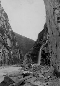
Keystone Canyon appeared to be the best glacier-free
route from coastal to interior Alaska, but its sheer cliffs made finding
a route difficult. Miles Brother photo from the Clifton Collection.
While Abercrombie was making his pack-train traverse of the glacier into the interior, the search continued for an alternative glacier-free route suitable for pack animals. On September 2nd, Corporal Heiden, who had been on both Brookfield's and Cleave's expeditions, departed Valdez for Keystone Canyon with a party of three enlisted men and ten pack animals. He, too, encountered heavy rains that "caused the glacial streams to swell " washing the men and horses off their feet several times and making the Lowe River impassable. They spent the time waiting for the rain to stop "cutting trail through the dense growth of alders and graded the hillside, which was extremely hard work (Heiden in Glenn and Abercrombie, p. 605)." When the rain and river subsided, Heiden moved Camp to Keystone Canyon whose "walls on both sides are almost perpendicular, rendering it necessary, therefore, to find a route around one of its sides." The route through this section was so difficult that they had to make three camps in 2-1/2 miles, but once on the other side, they "had about 4 miles of comparatively easy traveling (Heiden, p. 605)," through the area now called "Dutch Flats" after the three Dutchmen who befriended Cleaves' party.
At the head of Dutch Flats, Heiden chose the northern route, possibly Jackson's, that everyone hoped would connect to the claims at Quartz Creek and to the Copper River above Woods Canyon. He expected to meet Schrader who was instructed to pioneer the other end of the route from Copper Center over the Tsaina. As the rain turned to snow, Heiden's men cut a trail toward the pass through miles and miles of alder brush and windfalls. Meanwhile, an advance party returned with the welcome news that a pack train could make it over the pass. . . .
The mission was a success: they had cleared a trail through the Keystone area and confirmed a pass to the Tsaina River on the other side. . . .
Starting the Trans-Alaska Military Trail:
Before Abercrombie returned to Valdez in April of 1899 to begin work on the Trans-Alaska Military Trail, prospectors like Millard, Amy, and McClellan were already extending Heiden's trail. Over the winter, they had heard stories of nuggets of almost pure copper that a prospector had purchased from Chief Nicolai. In the great race to locate Chief Nicoli's copper deposit, McCarthy, Millard and others did not wait for the soldiers to build them a road. They did it themselves. However, prospectors cutting trails generally considered only the easiest and fastest route.
By contrast, Lt. Walter C. Babcock who mapped and organized the 1899 road building efforts had to find a route that could withstand heavy pack-train traffic, year after year. He began work on April 26th from Station No. 2 near Keystone Canyon. In siting the route, Babcock had to consider the gradient, which had to be suitable for pack trains and dog sleds; the number of river crossings, the need for bridges and risk of flooding. He also had to take into account the hardness of the terrain; horses' hooves could turn soft or boggy areas into a muddy quagmire.
Babcock divided his work force into three components: the advance crew surveyed the terrain and laid out the course; advance workmen brushed out the trail; and the trail gang actually built the road. Babcock began the road about 1/2 mile west of Keystone Canyon, switchbacking it up to a bench about 700 feet above the river, then sloping it down to a natural bench about 300 to 450 feet above the Canyon.
He soon appreciated the efforts of his advance team as they struggled along the steep slopes covered with slide alder:
The effort of climbing over, under, and through this brush on a side hill so steep as to scarcely afford a foothold; falling, stumbling, grasping at the devil clubs; bruised and beaten by the stout alder branches, and, at the same time, endeavoring to blaze out a line with a uniform grade or on a level is simply inconceivable to one who has not tried it. Frequently this has to be done many times before a line is secured that is considered the best possible (Babcock, p. 61).
It took the advance party six hours to cover the first three mile section of Keystone Canyon and more time was required to return to camp by a slightly different route. They did this four times before selecting the final route.
Conditions were no easier for the work parties. Axmen "had to support themselves by hanging to the brush with one hand while they chopped with the other (Babcock, p. 61)." To make a five foot roadbed, graders had to made 15 to 20 foot vertical cuts. The four miles through Keystone Canyon crossed fifteen mountain streams, eleven of which required the construction of retaining walls. One bridge was built.
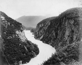
Looking down on the Lowe River from the Military Packtrain Trail in Keystone Canyon. 1903. Miles Brothers photograph. Courtesy Valdez Museum and Historical Archives.
Not only was the Keystone Canyon section the most difficult, it also had to be completed in a rush so the post-office inspector and his outfit could begin their trip to Eagle. On June 11th, Abercrombie dispatched 11 more men to help and "by 5 p.m. Saturday, June 17th, the trail was ready for the pack trains to go in." Babcock writes with obvious pride that "the key of the whole route, was constructed in thirty-five working days (Babcock, p. 62)."
Even though the route beyond Keystone Canyon to Copper Center still was not finished, government parties and prospectors started moving over the road. On June 18th, John Rice accompanied Mr. Wayland, the postal-inspector, and five pack horses to test the feasibility of a mail route to Eagle City on the Yukon. On June 19th, 38 more pack horses and 9 dogs went north; and so it continued all summer. A government pack train and the Young and Downy party, raced along the new trail to catch up with the combined Millard, McCarthy and McClellan parties. By July 27th when the trail was completed to the summit of Thompson Pass, traffic was so heavy Babcock had to dispatch a man with sufficient tools to spend the rest of the season patrolling and repairing the road. Babcock writes to his superiors that "Many prospectors were constantly coming and going over the road, and all expressed their satisfaction and relief at having a road to travel that avoided the dangerous Valdez Glacier, and shortened the journey from the interior by several days (Babcock, p. 64)."
In mid-July, Babcock decided that he, Mr. Worthington, his transit man, and two packers would be the advance party to map the route from Thompson Pass to Copper Center. From Thompson Pass, they followed Ptarmigan Creek down to Tsaina then along the edge of Tsaina Valley, across the low divide to the north fork of the Tiekell River, where they worked their way through the remains of a recent forest fire, past Stewart, Boulder, Ernestine and Falls Creeks. Here they reported abandoned prospecting camps and a few prospectors still at work. They then continued across the low divide to the Tonsina Valley.
Babcock and Worthington found the stretch between Stewart and Boulder Creeks the most difficult to map because the stream, wandering extensively back and forth across the valley, had undercut banks and deep pools. Many beaver dams pocketed the valley, but the prospectors had killed off all the beaver. Heavily forested, the valley was covered with a thick understory of alders and willows, currents and wild roses - all seemingly designed to obstruct a surveyor's view. It took them five days to map the seven miles to Boulder Creek where they encountered the charred remains of Tiekell City.
At Tonsina, with the summer running out, Babcock encountered wet, boggy ground totally unsuited for packhorse travel. Discouraged, he and Worthington criss-crossed the area looking for a route. Luck was with him, however. His new packer, Christopher Tjosvig, arrived. Tjosvig, a prospector, had explored the Quartz Creek and Tonsina area in 1898. He showed Babcock a more direct route to Tonsina that ran through the divide between the South Fork of the Tonsina and Bernard Creek. Babcock named this Kimball Pass. At Bernard Creek, he sketched in the military road across the Tonsina and then along Trout Creek and over the last bit of coastal mountains down to a place on the Klutina about 8 miles above its confluence with the Copper River. A good bridge site here had already been selected. Babcock concluded the summer feeling satisfied with both the geology and grades for the final stretch. The military could build a road to Copper Center.
By the end of the season, Babcock's road gangs had completed 93 miles of the Trans-Alaska Military Trail which were suitable for packhorses, 35 miles which were in excavation, 67 miles cleared and brushed, and 12 miles cleared only. In addition, they had built 26 bridges, not including culverts, totaling 856 feet. The width of the road varied from five feet in Keystone canyon to ten feet elsewhere.
The Richardson Highway now follows approximately this route. In many cases, the roadbed has been shifted to the valley to avoid avalanche slopes. With the aid of modern road building equipment, the route now lies on a gravel roadbed across the wetlands - a possibility not available to Babcock.
When Rice returned from his trip to Eagle City with Postal Inspector Wayland, he confirmed that a road could be built all the way to the Yukon.
The route over which we traveled from Port Valdez to Eagle City presents no such obstacles as the route through the Cascade or Rocky Mountains. The pack trail now constructed through the Coast Range by Captain Abercrombie could be transformed into a wagon or railroad bed. No glaciers are to be encountered nor any other serious obstacles. (Rice, in Glenn and Abercrombie, p. 102).
At the end of 1899, the United States had established the feasibility of an All-American, ice-free route to interior Alaska and the Klondike Gold Fields.
However, the summer's survey work was not without its mishaps. In crossing one of the glacial streams, which Babcock describes as only 15 feet wide and about 18 inches deep, the expedition almost met failure. Babcock reports that just as Mr. Worthington reached the far side, he was struck by a moving boulder. Suddenly, he disappeared in the water and was swept downstream, while trying to hold onto his gun and the surveyor's transit. Babcock ran alongside. "After a few minutes' struggle he crawled out on the side from which he had started. He still had hold of the gun, but the transit and hand ax were gone (Babcock, p. 65)."
The situation was serious. Without a transit, they could not complete
their summer's assignment. Since it was late in the day, when the stream,
fed by melt-water was at its highest, Babcock and Worthington camped waiting
until morning when the stream flow would be less. They could then try diverting
the stream. The next morning, to their relief, they found the transit caught
in a snag a quarter of a mile downstream, damaged, but fortunately still
usable. The glacier near Worthington's mishap today bears his name.