Maps of the Valdez Glacier Route


Map 1) Allen's 1885 Map based on Lt. Abercrombie's Report

Map 2) Valdez Glacier Route (section of next map)

Map 3) Valdez to Cordova from Schrader's 1899 Map

Return to home page


Allen's 1885 Map of the Valdez Glacier Route
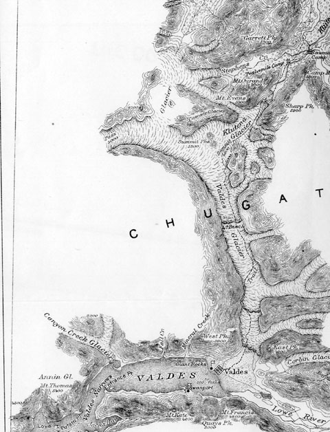
Based on Lt. Abercrombie's Report


Map 1


Note that this map shows Valdez Glacier to be an east/west running glacier. In fact, the glacier runs north/south as shown on Schrader's1899 map. Lt. Abercrombie probably never crossed Valdez Glacier but instead relied upon second-hand reports. The discrepancy in the 1885 map, the only map the 1898 gold rushers had, caused great confusion among the prospectors.


Valdes (Valdez) Glacier Trail to Klutina Lake
Map 2


Note that the Valdez Glacier runs north/south. Lt. Abercrombie may have ascended Corbin Glacier in 1884, but no lake is visible from either Corbin or Valdez Glacier's summits.

Klutina Lake (Lake Abercrombie) to Copper Center, Copper River and Cordova
Map 3
Note that the route through Keystone Canyon which became the Military Pack Train Trail or Valdez Trail in 1899 and was upgraded to a wagon road between 1905-1909 is marked as a "probable route" on this map. Today, the Richardson Highway and Alyeska Pipeline follow this route. It was the first land-based route on American territory to Alaska's interior and the only road to the interior until 1942.